We are occasionally confined to the great indoor wasteland of the desk, corner office, or garret. There we stare at a computer screen all day, with no opportunity to roam the precious spaces on earth. (Of course there is Google Earth, but the emptiness of that world wearies after a time. And, let’s face it, it’s a little flat. Very odd that technology has proved Columbus and Galileo wrong, and that indeed the Google Earth is flat.)
Because we need a means of escape, we have taken to downloading PDFs of ski trail maps as an escape or, at a minimum, an alternative to the flatness of satellite imagery.
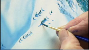
Do this long enough and you see the name of James Niehues crop up again and again. Niehues, 65, is the painter behind millions of maps handed out by ski resorts in North America, Japan, Korea, China, New Zealand, Australia, Chile and Serbia. He’s created about 300 panoramas in the past quarter century—mostly ski trails but also golf courses, hiking trails and other destinations.
But it’s the ski trail maps that decorate our walls. His uncanny manipulation of topography and scenery produces trail maps that test the bounds of reality—double black chutes look doable, slow green runs look fascinating—but still convey an understandable view of what can be at times a confused maze of lifts and trails.
It’s an art form that doesn’t get its fair share of attention, but Niehues has been in the spotlight recently: a newspaper article, a segment on NBC Nightly News.
Good coverage, but we think the work transcends what’s been said so far. His renderings remind us of the great Peruvian pin-up illustrator Alberto Vargas. The same brilliant colors, similarly lush landscapes. Both manage to merge fantasy and topography. And both leave us with a catalog of images that defy the cubicle.
V


